
About this page
How gusts really behave. Do they always veer? Brief notes on some other changes in wind.
Preamble
Challenging some accepted wisdom regarding the behaviour of gusts. We argue that gusts occur for more than one reason and while some do veer, others do not. The behaviour of gusts is one piece of weather folk lore that sometimes works as expected but sometimes not. In another page, on wind bends, Mike Brettle, who used to work in the UK Met Office Boundary Layer branch has challenged some of the accepted ideas regarding the way in winds behave across the coast. We are doing similarly here for gusts.
Related pages
On this page -
The Background
There is conflicting advice regarding the question of the wind "veering in gusts". This is the concept that, in a gust, the wind direction tends to change consistently, veering clockwise in the northern hemisphere. This idea originated in a very detailed research paper by the Met Office in the late 1920s at Cardington, the home of airships. This was published as "The Structure of Wind over Level Country" . Detailed studies were made of wind records at the ground and on masts on a fairly small number of occasions during 1928 and 1929. The main findings were in relation to one minute averages of wind although there were usually smaller fluctuations on the time scale of seconds. The findings are divided into three groups.
- In unstable air masses, that is to say ones in which there is convection and cumulus cloud forming. These were occasions when it was deduced that eddies were around 1000 by 200 metres in size. These eddies generally moved with the wind. Wind strengths would suddenly increase and then decrease slowly. There is no mention of these gusts veering.
- When there were unstable conditions but occasions when there seemed to be larger eddies of around 20 or more km as well as smaller eddies of the 1000 metre size. Strong gusts usually occurred after a rise in temperature and usually veered. The presence of large cloud masses was mentioned and, sometimes, rain.
- When there was a temperature inversion. that is to say that there was no convection. Winds were much steadier, gusts were random in directional change. Eddies were much smaller than in the other two cases.
The finding that "Strong gusts are associated with a wind from a more veered direction than lulls." was publicised by Alan Watts in his book Wind and Sailing Boats. and subsequently promoted by David Houghton and a few others.
On the other hand Frank Bethwaite, in his book High Performance Sailing says that this effect does not occur and he shows wind data from the 1976 Montreal Olympics as proof. Neither Mike Brettle nor I know of any peer-reviewed papers in meteorological journals giving any evidence for 'veering in gusts'.
Moreover, in the 1980's the Met Office published a number of studies addressing this issue without finding anything significant. One of these used a gust definition based on a yachtsman's perception and data collected in the conditions said to produce the strongest "veering in gusts" effect. Out of 132 gusts in the dataset as many backed as veered.
Either "veering in gusts" is more folklore than science or, as so often happens in meteorology, we are seeing the dangers of generalising from a small number of particular cases. Thorough though the research was, it was before the age of computers and relied much on hand analysis. A larger sample might have led to somewhat different conclusions, or conclusions with more caveats.
Wind and Sailing Boats, (1965, second edition 1973), is well worth reading for its observations on wind behaviour. Some of the theory might not hold water in these days of greater understanding. Nevertheless, most dinghy sailors and many sailors of larger boats will get some useful information.
The Theory of the veering gust and why or when it breaks down
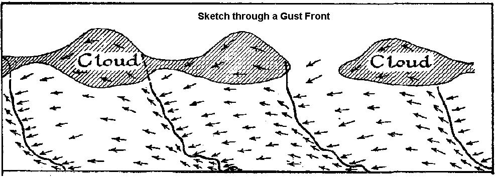
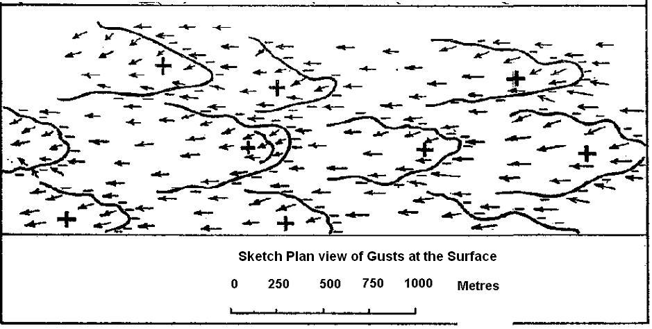
These diagrams shows the suggested structure of wind associated with convective clouds based on the research mentioned above. The left hand diagram is a vertical cross section, the right hand diagram is a plan view. The diagrams are taken from the research paper, M.O 331d, 1933, and were used by Alan Watts in his book.
Discussion
The explanation given in the research paper and shown above and here is that a gust in convective weather results from air brought down from aloft. Heating one part of the surface more than nearby areas creates lower pressure. This leads to an inflow and rising air with compensating descent. Small cumulus cloud like this are likely to form.
Since wind aloft is generally moving faster and is veered relative to that at the ground the argument goes that this means a gust should show a veered direction. To what extent descending air retains its faster speed, as simple theory has it, is uncertain.
However, conservation of energy comes into play. A mass of air, m, at a height H has potential energy = mgh. That is the work done against gravity to raise the air to that height. As the air descends in a downdraught, that energy is converted to kinetic energy. So, by the time that air reaches ground level it will have gained speed so that its kinetic energy = 1/2 m V2 = mgh. In general terms,
1/2 m V2 + mgh will be comstant.
Gusts on a larger scale, say gusts lasting tens of seconds, can be the result of convection in an unstable atmosphere. Convection currents in the atmosphere can exist on large scales, of kilometres or more, and can be well organised. The up-draughts and down-draughts can extend over a thousand metres or more into the atmosphere and convective gusts could represent air from some distance above the surface.
More vigorous convection will lead to air from greater heights being brought down to the surface with correspondingly stronger gusts. That all sounds and is very sensible, but is only a part of the story. First, when there are large shower clouds like this, the rain drags air down with it often at great speed - as fast as the rain falls. This descending air spreads out in all directions as in the sketch opposite and can give very strong gusts.
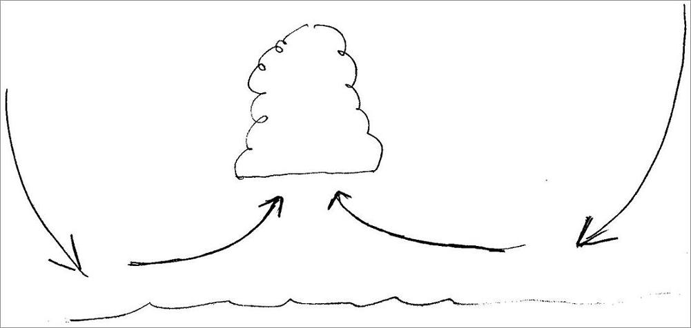
The upper diagram shows air rising due to convection from the surface. The compensating descending air will be relatively slow moving. It will bring air down ton the surface that is veered on the slower moving surface air. The lower diagram shows the effect of rain falling from a shower cloud and dragging air at great speed. A strong down-draught giving a blast of cold air can be the first sign of an impending shower.

Non-convective gusts
Secondly, some gusts are simply due to turbulence at the surface caused by the effects of friction and wind shear. This is essentially random and small scale. There may well be cases where wind descends from a higher level, a few tens of metres say, to the surface but generally surface friction slows the air down. In effect this means that turbulent gusts will be random and will not represent wind from any particular height above the surface.
In stable air, in particular, where there is little or no convection and therefore no interchange between air from the surface and air higher up, gusts are much less and generally random.
Convection can be organised into patterns and it may well be that on particular occasions yachtsmen may experience a regular pattern of veering
Further comments - the reality
From the above, it seems that winds can and do veer in some gusts. This is most likely when the air is unstable. However, the various effects of showers, surface friction, obstacles can all result in backing of the wind as well as veering. In other words, other effects can make application of the concept difficult, even in convective situations. In stable air, such as beneath a big high pressure area, in the warm sector of a low or at night then gusts will generally be random and caused by surface friction.
In other words, the theory fits where it touches.
Frank Bethwaite, despite his healthy scepticism does recommend racing yachtsmen to get out onto the water before a race and look for patterns.
This sounds like good advice so long as it is carried out without any false pre-conceptions.
Before the International 14s had a national championship at Llandudno many years ago, I remember that the leading helmsmen spent the previous week sitting on the Great Orme just watching - and noting - the various bends in the wind and how gusts behaved.
In summary, rather like the idea that winds veer as air crosses from land to sea, this is another example of the over-simplistic application of theory which has some good foundations but which is bedevilled by the complexity of the atmosphere.
Other changes in wind
On other pages we have talked about wind bends and sea breezes, both of which are important to the sailor.
An effect that has been given publicity is the strength of wind when the direction is near parallel to the coast. When the coast is to the right (looking down wind) the winds are likely to be stronger than in the reverse direction. The theory is complex, much more so than simply the usually quoted effects of friction causing convergence or divergence of the air. An interesting example is the wind funnelling through the Dover Strait. Strongest winds, a low level jet in fact, will occur some distance downstream. With a NE wind, the strongest winds will be on the English side of the Channel and occur near the Greenwich Light Vessel.
On the "Bends" page it was noted that in the warm sectors of lows, and in stable (non convective air) air generally, winds will be more backed ie cross isobar towards low pressure than in unstable air. Winds behind a cold front will be more nearly along the isobars and much more gusty than ahead of the front. For a given isobar spacing, winds will be stronger in the unstable, post cold front air than in the warm sector.
Other significant changes in wind occur with fronts and troughs. The difference between the two may seem rather subtle to the sailor but it is really quite simple. A front is where air streams from different areas meet each other. Warm air overtaking cold air is a warm front. Cold air overtaking warm is a cold front. At both there is an area of rising air leading to lower pressure at the surface. This result in a trough of low pressure out from the centre of low pressure.
Wind changes at fronts can vary greatly from being barely discernible to nearly 180 degrees. There can be a very sudden veer, or one that is almost non-existent. Just before a front passes, the wind may back a little more before it veers at the front.
A trough can simply be a bend in the isobars created perhaps by a lot of convection or, maybe, the downstream effect of high ground. The converse of a trough is a ridge of high pressure extending from a high pressure area. The change of wind direction can be quite gentle as a trough passes and even more gentle as a ridge passes.
Return to Home Page